
Tropical Storm Erin Graphics
5-Day Uncertainty Track last updated Wed, 13 Aug 2025 02:41:04 GMT Wind Speed Probabilities last updated Wed, 13 Aug 2025 03:21:58 GMT
Tropical Storm Erin Graphics

5-Day Uncertainty Track last updated Wed, 13 Aug 2025 02:41:04 GMT Wind Speed Probabilities last updated Wed, 13 Aug 2025 02:41:04 GMT
Tropical Storm Erin Forecast Discussion Number 7
Issued at 1100 PM AST Tue Aug 12 2025 817 WTNT45 KNHC 130238 TCDAT5 Tropical Storm Erin Discussion Number 7 NWS National Hurricane Center Miami FL AL052025 1100 PM AST Tue Aug 12 2025 Deep convection has
Tropical Storm Erin Wind Speed Probabilities Number 7
Issued at 0300 UTC WED AUG 13 2025 000 FONT15 KNHC 130237 PWSAT5 TROPICAL STORM ERIN WIND SPEED PROBABILITIES NUMBER 7 NWS NATIONAL HURRICANE CENTER MIAMI FL AL052025 0300 UTC WED AUG 13 2025 AT 0300Z THE
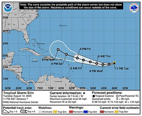
Tropical Storm Erin Public Advisory Number 7
Issued at 1100 PM AST Tue Aug 12 2025 795 WTNT35 KNHC 130236 TCPAT5 BULLETIN Tropical Storm Erin Advisory Number 7 NWS National Hurricane Center Miami FL AL052025 1100 PM AST Tue Aug 12 2025 …ERIN LIKELY
Summary for Tropical Storm Erin (AT5/AL052025)
…ERIN LIKELY TO BECOME A HURRICANE OVER THE CENTRAL TROPICAL ATLANTIC IN A COUPLE OF DAYS… As of 11:00 PM AST Tue Aug 12 the center of Erin was located near 16.7, -40.1 with movement W at
Atlantic Tropical Weather Outlook
000ABNT20 KNHC 122336TWOAT Tropical Weather OutlookNWS National Hurricane Center Miami FL800 PM EDT Tue Aug 12 2025 For the North Atlantic…Caribbean Sea and the Gulf of America: Active Systems:The National Hurricane Center is issuing advisories on Tropical
Tropical Storm Erin Graphics
5-Day Uncertainty Track last updated Tue, 12 Aug 2025 20:35:05 GMT Wind Speed Probabilities last updated Tue, 12 Aug 2025 21:21:36 GMT
Tropical Storm Erin Wind Speed Probabilities Number 6
Issued at 2100 UTC TUE AUG 12 2025 554 FONT15 KNHC 122032 PWSAT5 TROPICAL STORM ERIN WIND SPEED PROBABILITIES NUMBER 6 NWS NATIONAL HURRICANE CENTER MIAMI FL AL052025 2100 UTC TUE AUG 12 2025 AT 2100Z THE
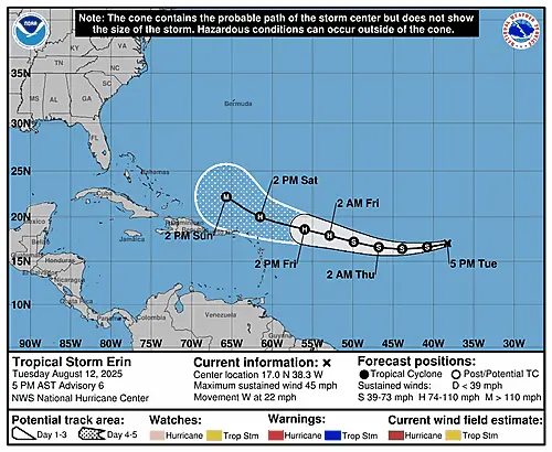
Tropical Storm Erin Forecast Discussion Number 6
Issued at 500 PM AST Tue Aug 12 2025 050 WTNT45 KNHC 122033 TCDAT5 Tropical Storm Erin Discussion Number 6 NWS National Hurricane Center Miami FL AL052025 500 PM AST Tue Aug 12 2025 Not much has